Highway Code: Route Navigation Challenge 2
Free Direction Signs Practice Test 2: UK Traffic Signs Theory Test
Interactive Revision Tool & Navigation Signposts Checkup
🗺️
Primary Target
Distinguish primary, local & motorway networks
📋
Quiz Structure
Multiple-Choice Evaluation (3-4 options)
💡
Live Feedback
Immediate grading with contextual feedback
- Evaluate your ability to identify and decipher directional signposts found across UK roads.
- Select the single best answer from the three or four available choices.
- Correct entries illuminate in green right away, while incorrect picks show up in red.
- A detailed diagnostic breakdown follows any incorrect selection to reinforce standard road laws.
This sign is used to identify:

A museum entrance.
A railway station.
A tourist information facility.
A viewpoint lay-by.
This sign shows the location of a tourist information point, where visitors can get maps, guidance, and local details.
What does this sign indicate?

Nature reserve.
Picnic site only.
Country park.
Adventure playground.
This sign shows the location of a country park, a publicly accessible natural area for recreation, walking, and outdoor activities.
What does this sign indicate?
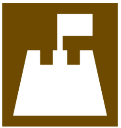
Lake.
Beach.
Swimming pool.
River.
This sign shows the location of a beach, a sandy or pebbly area beside a sea, lake, or river that is open for public recreation.
What does this sign signify?

Public picnic area.
National Trust property.
Country park only.
Private land — no entry.
This sign shows that the location is managed or owned by the National Trust, an organisation that protects historic places, countryside, and natural landscapes.
What is the name of this sign?
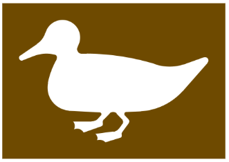
Nature reserve.
Bird garden.
Country park.
Farm park.
This sign shows the location of a nature reserve, an area protected for wildlife, plants, and natural habitats, often open to the public for observation and education.
What does this sign indicate?

Local council office.
National Trust property.
Private museum.
English Heritage site.
This sign shows the location of an English Heritage site, which is managed by the organisation responsible for protecting and preserving historic monuments, buildings, and places across England.
What does this sign represent?

Temporary road markings.
Overhead signs.
Side-mounted hazard boards.
Village boundary signs.
Overhead signs display lane, speed, and direction information above the carriageway.
What does this sign indicate?

Museum.
Art gallery.
Tourist information.
Historic site.
This sign indicates the location of a museum in England, where historical, artistic, or scientific exhibits are displayed for public education and enjoyment.
What does this sign indicate?

Wildlife sanctuary.
Zoo.
Nature reserve.
Safari park.
This sign indicates the location of a safari park, a wildlife park where visitors can drive through and observe animals in open or naturalistic habitats.
What does this sign mean?
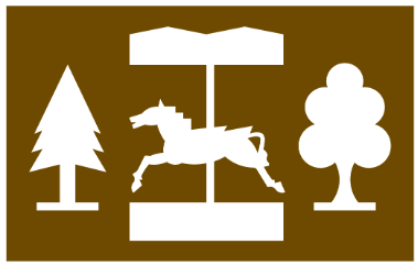
National Trust property.
Theme park.
Tourist information.
Historic site.
This sign indicates the location of a theme park, a recreational area with rides, attractions, and entertainment for visitors.