UK Road Signs: Route Navigation Test 1 of 2
Free Direction Signs Practice Test 1: UK Traffic Signs Theory Test
Free Practice Test & Identifying Direction Signs
Core Objective
Identify primary, local & motorway routing
Format Layout
3 to 4 Option Multiple-Choice
Real-Time Review
Instant answers with explanations
💡 What You Must Know:
Direction signs are part of the official UK theory test. They help drivers find their way by pointing to destinations, junctions, and exits. Colours and layouts vary depending on the type of road (e.g., blue for motorways, green for primary routes, white for local roads). They include arrows, names, and distance info. For example:
➡️ Town / City target
↖️ Multi-exit layout
🏁 Destination point
- You’ll practise identifying and understanding direction signs used on UK roads.
- Each question includes three or four options to choose from.
- After you answer, correct choices will be highlighted in green, and incorrect ones in red.
- If your answer is wrong, an explanation will help you understand the correct direction or route.
What does this sign indicate?
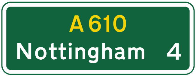
Service station available.
Warning of roadworks.
Route confirmation.
Pedestrian crossing ahead.
It reassures drivers that they are following the correct route and lists major destinations.
How are non‑primary ‘A’ roads signed, compared to primary routes?
White background and black numbers/letters.
Green background and yellow numbers.
Blue background and white text.
Brown background with white lettering.
Non‑primary routes use white backgrounds with black text and route numbers, even if they have an A‑number.
Route numbers on direction signs always begin with which letter if the road is a primary route?
B
A
M
C
Primary routes are always given an ‘A’ number, e.g. A1, A38.
What is the purpose of countdown markers?
Show diversion routes.
Warn of low bridges.
Indicate distance to a deceleration lane or junction.
Mark emergency stopping areas.
They show how far you are from the start of the deceleration lane or junction.
“Stack‑type” direction signs are most likely used for which situation?
Constrained urban crossroads.
Complex roundabouts.
Service area signs.
Emergency diversion routes.
Stack‑type signs are compact and used for simple or space-tight junctions, such as urban crossroads, unlike map‑type signs.
How are countdown markers shown on non-primary routes?
Blue bars on white.
Yellow bars on black.
Black bars on a white background.
Red bars on white.
Non-primary route countdown markers use black bars on white.
Which of the following would most likely appear on a brown direction sign?
A local school.
A business park.
A motorway junction.
A tourist attraction.
Brown signs are used for tourist destinations, including heritage sites, leisure parks, and cultural attractions.
What does this sign indicate?
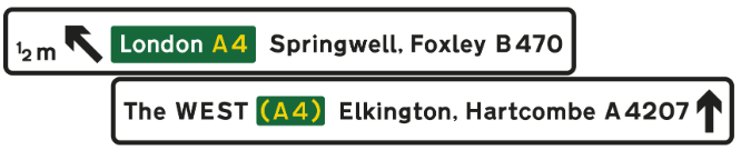
A primary route.
A motorway route.
A tourist route.
A non-primary route.
The white background shows it is a non-primary route sign used for local roads.
Primary routes on all‑purpose roads: which features correctly match direction signs?
White background, black lettering.
Blue background, yellow lettering.
Green background, yellow route numbers, white text.
Brown background, white text.
Signs on primary routes always have green backgrounds, yellow route numbers, and white lettering.
The purpose of this sign is to:
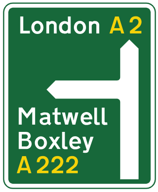
Indicate a motorway start.
Warn of a single-lane bridge.
Show a junction between two non-primary routes.
Show a junction between two primary routes.
It provides advance warning of a major junction to help drivers adjust speed and lane position.
What information does this sign provide at a junction?
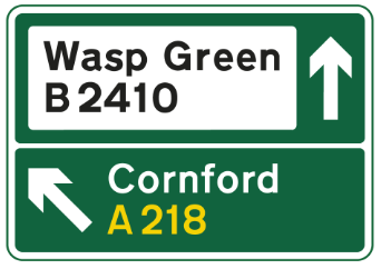
Primary and non-primary route.
Only a non-primary route.
Only a primary route.
Lane closure.
The rectangular sign shows directions for a primary route and a non-primary route at a junction.
Which statement best describes the routes shown on this sign?
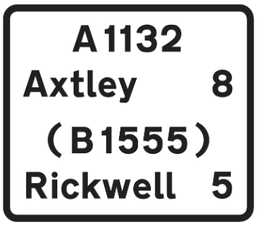
Axtley ahead; Rickwell via B1555.
Both destinations require a right turn.
The B1555 leads to Axtley.
Both towns are on the current route.
The sign confirms the current route continues to Axtley, while Rickwell is accessed by turning onto the B1555.
On this sign, non-primary routes are shown using what colour panels?
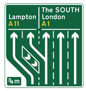
Blue.
Green.
White.
Brown.
Non-primary routes are displayed in white panels on advance direction signs—even when they intersect primary routes.
What term describes a road that is not a motorway but connects towns or regions?
B‑road.
Local road.
All‑purpose road.
Expressway.
Roads other than motorways are classified as all‑purpose roads, encompassing primary and non‑primary routes.
What does this sign indicate?
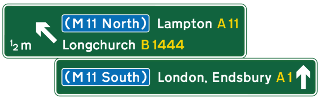
A non-primary route.
A motorway-only route.
A temporary diversion.
A primary route.
This sign indicates a primary route, shown with a green background and white text. Primary routes connect major towns and cities and are designed for long-distance traffic.
What do countdown marker bars represent?
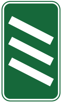
50 yards each.
Around 100 yards each.
Speed limit zones.
Number of lanes available.
Each bar on countdown markers equals roughly 100 yards.
What type of sign is shown below?
Stack‑type direction sign.
Route confirmatory sign.
Flag‑type fingerpost.
Map‑type direction sign.
Map‑type signs display the junction layout, including roundabouts, and scale road widths according to status - wide for primary/motorways, medium for non-primary A/B roads, and narrow for local roads.
What type of sign is displayed below?
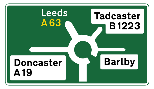
Stack-type sign.
Flag-type sign.
Map-type roundabout sign.
Route confirmatory sign.
This is a map-type direction sign, showing a roundabout layout with road widths scaled by route importance. The widest arm indicates a primary route.
What does this flag-type sign indicate?
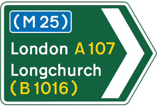
Motorway ends here.
Primary route leads to a motorway and a non-primary route.
Non-primary route only.
Emergency area ahead.
The flag-type sign shows a primary route splitting toward a motorway and a non-primary road.
Which colour panel would show a primary route on a sign from a non‑primary route?
Green.
White.
Blue.
Brown.
On non‑primary road signs, primary routes are shown in green panels to indicate their higher status.